Currently Completed Counties – Cornwall

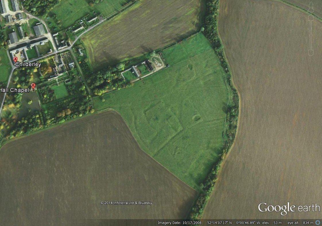
This week we look at one of the completed counties on the Beresford’s Lost Villages Website. This website lists all the settlements recorded by 1968 and gives a full description of the available evidence.

Deserted villages in Cornwall

No Cornish settlements were included when Maurice Beresford published his Lost Villages of England in 1954. This was not due to any lack of information but due to a slight publishing oversight. The list for Cornwall was later found slipped down the back of the piano when Maurice was moving in 1958 (Beresford 1971: 3). A total of 11 sites were recorded on the 1968 Gazetteer. Cornwall is highlighted as one of the 15 counties which require considerable local research, but it is unclear why some sites that had been identified in the 1960s did not make the original Gazetteer (Dudley and Minter 1962-63: 282-283). Since 1968 there has been sustained effort placed in surveying areas of the historic environment including one of the first examples of a county-wide history landscape characterisation (Herring 1998). The large-scale survey of Bodmin Moor by the RCHME has also been important to our understanding medieval Cornwall (Johnson and Rose 1994, Preston-Jones and Rose 1986: 139).

The landscape of current settlement in Cornwall (at least that on the first edition Ordnance Survey maps) has been said to reflect the medieval pattern of small hamlets and farmsteads (Preston-Jones and Rose 1986: 141). This dispersed settlement pattern is interspersed with closes (enclosed fields) and small-scale open fields (Rippon and Croft 2011: 195). The pattern though is varied and in some areas nucleated villages do dominate (Overton 2006: 109). The settlement form in Cornwall also varies, and many of the deserted sites consist of a cluster of buildings, sometimes with their own yards, but not the format of toft and croft seen in central England, and perhaps not the label of  ‘village’. Hence the website has classed most of the settlements in Cornwall as deserted hamlets.

Deserted villages as classified by the website

With this diversity of settlement evidence there has been a diversity of approaches to the study of  settlement in the county but in many ways this has led the research in England as a whole. Two pioneers in the study of deserted settlement not only in the South West, but also in England, were Dorothy Dudley and E. Marie Minter. They excavated a number of sites in both Cornwall and Devon. In fact Cornwall has seen some of the earliest excavations of village sites in the country.

Plan of the settlement at Trewortha, Cornwall (Baring-Gould 1895a)

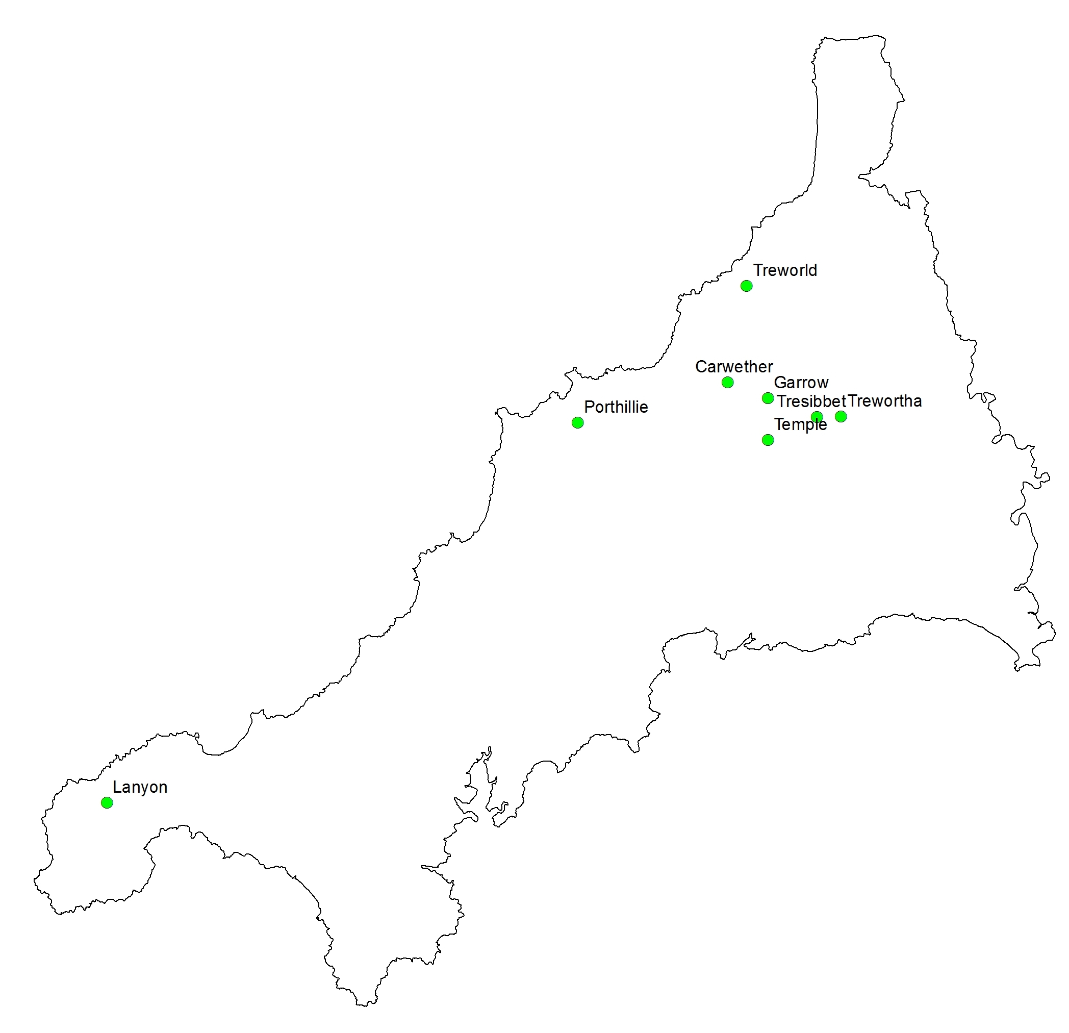
Of the 11 sites identified in 1968, four sites had been excavated by the time of the Gazetteer. Excavations in 1891-2 at Trewortha have been classed as one of the earliest excavations of a deserted medieval settlement, even if it was not identified as such at the time (Baring-Gould 1895a, 1895b). Initially excavated as it was thought to be evidence of prehistoric settlement, the only date that was given by the excavations was post-Roman (Baring-Gould 1895a, 1895b). The excavation revealed the remains of a number of stone buildings, typical longhouses of the area, although a more complex interpretation of a council house was given at the time (Baring-Gould 1895a).

Plan of building excavated at Trewortha, Cornwall
Plan of building excavated at Trewortha, Cornwall (Baring-Gould 1895a)

Dorothy Dudley and E Marie Minter worked together on a number of sites. In 1952 they excavated at Garrow looking at one house which they dated to the thirteenth to fifteenth century (Dudley and Minter 1962-63). Treworld in north-east Cornwall was excavated in 1963. A number of phases of activity were identified, with stone houses suggested from A.D. 1200. However preceding this has been a much debated phase which is said to consist of turf houses (Dudley and Minter 1966). In 1964 the site of Lanyon was excavated which revealed stone buildings from the twelfth century (Minter 1965, Beresford 1994).

More recently, the RCHME undertook detailed surveys of Garrow, Trewortha Marsh and Carwether as part of their survey of Bodmin Moor (Johnson and Rose 1994).

Carwether, Cornwall. Deserted settlement Copy right Google
Carwether, Cornwall. Deserted settlement Copyright Google

Many of the excavated sites, as well as those listed on the website, have been concentrated on what has been classed as marginal or secondary sites – areas which have seen settlement expansion (Preston-Jones and Rose 1986: 151). More research is needed in the lowland areas, the documentary evidence points to at least 750 settlements that are mentioned but have since been deserted (Preston-Jones and Rose 1986: 151).

A number of projects have been undertaken making public the information held by the Cornwall HER – they include a range of aerial photographs that can accessed at the Flying Past website at http://www.historic-cornwall.org.uk/flyingpast/. Many of the settlements on the website have excellent photos here….

References

Baring-Gould, S. 1895a. ‘An Ancient Settlement of Trewortha Marsh’, Journal of the Royal Institution of Cornwall 11: 57-70.

Baring-Gould, S. 1895b. ‘Ancient Settlement of Trewortha’, Journal of the Royal Institution of Cornwall 11: 289-90.

Beresford, G. 1994. ‘Old Lanyon, Madron: a Deserted Medieval Settlement. The Late E Marie Minter’s Excavations of 1964’, Cornish Archaeology 33: 130-169.

Beresford, M.W. 1954. The Lost Villages of England. London: Lutterworth Press.

Beresford, M.W. 1971. ‘A Review of Historical Research (to 1968)’, in M.W. Beresford and J.G. Hurst (eds.) Deserted Medieval Villages: Studies: 3-75. London: Lutterworth.

Dudley, D. and E.M. Minter 1962-3. ‘The Medieval Village at Garrow Tor, Bodmin Moor, Cornwall’, Medieval Archaeology 6-7: 272-294.

Dudley, D. and E.M. Minter 1966. ‘The Excavation of a Medieval Settlement at Trewold. Lesnewth, 1963’, Cornish Archaeology 5: 34-58.

Herring, P. 1998. Cornwall’s Historic Landscape: Presenting a Method of Historic Landscape Character Assessment. Truro: Cornwall Archaeological Unit.

Johnson, N. and P. Rose 1994. Bodmin Moor: An Archaeological Survey Volume 1: the Human Landscape to c. 1800. London: English Heritage.

Minter, E.M. 1965. ‘Lanyon in Madron: Interim Report on the Society’s 1964 Excavation’, Cornish Archaeology 4: 44-45.

Overton, M. 2006. ‘Farming, Fishing and Rural Settlements’, in R.J.P. Kain (ed.) The South West: 109-130. London: English Heritage.

Preston-Jones, A. and P. Rose 1986. ‘Medieval Cornwall’, Cornish Archaeology 25: 135-185.

Rippon, S. and B. Croft 2007. ‘Post-Conquest Medieval’, in C.J. Webster (ed.) The Archaeology of South West England: South West Archaeological Research Framework Resource Assessment and Research Agenda: 195-203. Taunton: Somerset County Council.

Progress report January 2015

Beresford’s Lost Villages website is still a work in progress. All 2,263 deserted village sites listed in 1968 appear on the site – each has an individual record with lots of useful information such a the taxation records, the number of the relevant record on the local Historic Environment Record (HER) and National Monument Record (NMR) as well as the suggested location of the site. This short report updates on the progress being made at adding further information to these records, which is being tackled on a county by county basis. Up to now we have managed to complete the process for the pre-1974 counties up to Essex. At the moment we are in the process of reviewing Gloucestershire.

What does this review entail?

Well it is at this point we check a number of aspects of the data for each settlement as well as writing a brief description of each site. In a future blog we will explore in more detail the process of writing a description of a site, but this entails locating as much information about the archaeology and history of the site, reviewing old maps, aerial photographs and evaluating the data that already forms part of the record. More often than not it is at this stage that we find the grid reference listed in 1968 in the Gazetteer of Deserted Medieval Villages (Beresford and Hurst 1971), is not actually placed over the site of the village. This may be due to recent work which has pinpointed the village more accurately, may be that the original location was placed over a particular feature such as a church, which is no longer seen as the centre of the settlement, or a simple error occurred in the original record. We have already found a number of typos that had occurred in 1968 with the wrong grid square letters being used for example. It is only really when sites are reviewed on an individual basis that these mistakes are picked-up. We are also thankful for the eagled-eyed users of the website who have been emailing in with corrections to the locations – it is really only when you have people with the specific local knowledge that these things are easily identified – please continue to let us know!!!!

Once all the evidence has been compiled – we then evaluate the material to categorise the site – is it a deserted settlement – or has it shrunk, migrated, shifted or actually is it doubtful there was ever a settlement there?

Gloucestershire

Progress so far on Gloucestershire is going well but was hampered by Christmas…. In 1968 there were 67 settlements listed – we have reviewed the evidence for around 50 of these so far… hopefully by the middle of February we will have completed this review and all the new data can be added to the website. As a taster of what is to come here are some highlights (full references to all sources will be available in the finished product) ….

Ampney St. Mary

There are two sites that have been classed as the deserted settlement at Ampney St. Mary – resulting in confusion. The church of St Mary stands isolated close to Ampney Brook. The church contains twelfth century elements.  This is the site that the HER and NMR record as the deserted medieval village of Ampney St. Mary.  The Gazetteer in 1968 listed the location as close to the current settlement of Ampney St. Mary (also known as Ashbrook). Here a field visit in 1988 noted areas of limestone rubble. All the evidence currently points to a settlement that at some point migrated locations.

Castlett Farm

At least 14 house platforms have been plotted at the site, along a northwest-southeast running hollow way. Medieval pottery was reported during construction work and an evaluation in 2005 revealed a ditch in-filled in the eleventh and twelfth century. Castlett is recorded in the Domesday Book with a minimum population of 4. In 1327 five people are assessed.  In 1334 a below average Lay Subsidy is paid. In 1381 four people paid the Poll Tax. The documentary evidence suggests a small settlement.

Farmcote

Farmcote was a grange of Hailes Abbey. A number of earthworks are associated with this grange and part of the existing farm and barn may be medieval in origin. The earthworks include croft platforms, hollow ways, and a fishpond. It is recorded in the Domesday Book with a minimum population of 17. In 1327 12 people were assessed. An average amount is paid in the 1334 Lay Subsidy. In 1381 26 people are taxed and by 1563 four households are recorded. There still exits a number of properties at this site and it appears to be a shrunken settlement.

Farmcote (c) Google Earth

Frocester

This site has been identified due to the presence of St Peter’s Church 1.5km to the west of the present settlement. The church has been mainly destroyed, but areas have been excavated which shows evidence of a Roman villa, followed by a Norman church constructed on the site. The area surrounding the church shows no evidence of settlement remains, but ridge and furrow is present. There has been extensive excavation and fieldwork carried out in the parish enabling a detailed understanding of settlement development from the pre-Roman period onwards. For further information on this project see Gloucestershire Archaeology.

It has also been shown that the parish of Frocester included a number of small dispersed settlements, many of which were abandoned in the thirteenth century. There is no clear evidence of settlement in the area of St Peter’s Church and a variety of reasons for the isolated location of the church can be postulated.

Frocester - St Peter's Church (c) Google Earth
Frocester – St Peter’s Church (c) Google Earth

Hullasey

Extensive earthworks of the village of Hullasey are now engulfed in Hullasey Grove, which has preserved the remains, some which stand to 1m high.  They include a north-south hollow way with a shorter east-west section at the southern end. A survey in 1981-2 recorded 30 buildings and a possible five others. A chapel existed by 1349 and was still there in the eighteenth century but by this time was used as a barn. Excavations in 1907 revealed two houses and a large building which was suggested to be the manor house, but has more recently described as four separate buildings. The excavations also located the chapel.  From both the archaeological and historical evidence it would suggest this settlement was deserted in the fifteenth century.

Hullasey Grove (c) Google Earth

As work progresses we will keep you informed.

As to the future developed of the website it is hoped that funding will be secured to enable the lists of deserted settlements in all counties to be brought up-to-date….

Currently Completed Counties – Cheshire and Cumberland

Welcome to the blog highlighting the website ‘Beresford’s Lost Villages’ and the material that can be found there, continuing the review of the counties were it has been possible to provide full descriptions of all deserted villages listed in the Gazetteer of settlements in 1968. This week we look at two northern counties that were both highlighted in 1971 as needing further local research to provide a real picture of the nature of deserted settlement in the area – Cheshire and Cumberland (Beresford and Hurst 1971).

Only four settlements in Cheshire and eight settlements in Cumberland appear in the 1968 Gazetteer.  In both counties there is also a clustering of sites into regions where some fieldwork had been undertaken. For Cumberland it is a little confusing why some of the earlier work in the county had not been used when compiling the list. For example in 1963 William Rollinson published a paper entitled ‘The lost villages and hamlets of Low Furness’ (Rollinson 1963). This suggested at least five lost settlements in this one small area. It also explored theories from the 1770s onwards as to why these settlements disappeared including tidal inundations and monastic developments.

Cheshire
Deserted villages in Cheshire recorded in 1968

Since 1968 a number of surveys have taken place as well as a consideration of the nature of settlement in these counties during the medieval period. In 1975 the MVRG noted that over the last four years much work had been undertaken on Cheshire with the documentary sources but that fieldwork needed to be done (Dyer 1975). Work by a number of individuals including D. Sylvester had noted the dispersed nature of settlement in a number of townships (Dyer 1975). It is now clear that this is a much more widespread pattern and that Cheshire as a whole had a great deal of dispersed settlement so the exact nature of the village and settlement make-up is difficult to reconstruct. Many of the settlements that become classed as deserted may not have been large nucleated entities in the first place. Many townships by the nineteenth century still contained no nucleated settlements (Edwards 2007). The main concentration of nucleated settlement in Cheshire is located to the west of the central Cheshire ridge (Dyer 1975).

A similar pattern can be seen in Cumberland. With many of the sites identified in Cumberland it is questionable whether there was ever extensive nucleated settlement at these locations. The documentary record is patchy, but those settlements with records seem to have declined in the fourteenth century. Analysis of the general settlement pattern over much of Cumbria has also highlighted the high percentage of dispersed settlements consisting of single farmsteads or a couple of dwellings (Newman 2006, 2009). The landscape of the area is varied though and in some areas classical nucleated settlement can also be found. This pattern seems to have a long history. Not only does this make understanding the true pattern of desertion across the county difficult, there is also the issue that it can be difficult to identify medieval dispersed settlement as they are ‘more easily rendered ‘invisible’ by later land use’ (Newman 2006: 121). The Research Agenda for the North West has prioritised the investigation of evolution of dispersed settlement and to investigate the ways settlement expanded into marginal areas in the Medieval period (Newman and Newman 2007).

Deserted villages in Cumberland

With this dispersed nature of settlement in both counties, it has led to many of the settlements listed in 1968 being now classed as doubtful deserted medieval settlements as it is unclear whether a nucleated settlement ever existed at that location. One of the key challenges with these regions is the patchy existence of medieval taxation documentation – often key to plotting the existence and development of medieval populations.

The palatine of Cheshire was exempt from most medieval taxation so few records appear after the Domesday Book until the sixteenth century. Cumberland in some periods belongs to Scotland, at other times it is exempt from taxation due to Scottish raids and troubles. Cumberland was not recorded in the Domesday Book, however a small number of places are recorded in the Domesday record for Yorkshire, but this is limited to just four places (Faull and Stinson 1986). In 1334 there is no Lay Subsidy for Cheshire and for Cumberland there was no tax due to recent devastation by the Scots so Glasscock (in his publication of the Lay Subsidy) has substituted this with the 1336 tax figures allowing some indication of the presence of settlements (Glasscock 1975: xxiii). It is suggested that due to ongoing devastation from the Scots the payments are probably low (Glasscock 1975: 36).  In 1377 no writ was issued for the Poll Tax in Cheshire. In 1379 commissions were supposed to levy the tax, but this was cancelled and they were asked for an offer of aid instead (Fenwick 1998: xxi). The Crown confirmed Cheshire’s immunity from parliamentary taxation in 1381 (Fenwick 1998: xxi). Although Cumberland was taxed in the fourteenth century there has been limited survival of the documents for the whole of Cumberland. Only one nominative list has survived from the 1377 Poll Tax (Fenwick 1998: 90). While this membrane is in good condition, it refers solely to Carlisle and does not refer to any of the deserted settlements. There are no surviving records for 1379 or 1381. Again in the sixteenth century no Lay Subsidy was required in 1524, 1525 or 1543 for both counties (Sheail 1998: 3).

Overall these two counties are representative of a situation outside the main ‘planned’ landscapes of central England. The nature of dispersed settlement, but also very variable local settlement patterns, results in a different type of challenge when trying to evaluate the extent and nature of settlement desertion. Much work has already been done tackling these regions and it is anticipated that once the Beresford’s Lost Villages Website Project moves into the next phase of updating the 1968 county lists, that these two counties will see a dramatic increase in the number of settlements recorded – although the number of ‘nucleated’ settlements may be limited and more evidence of deserted hamlets may well be apparent.

 References

Beresford, M.W. and J.G. Hurst (eds) 1971. Deserted Medieval Villages: Studies. London: Lutterworth Press.

Dyer, C. 1975. ‘Research in 1975: Cheshire’, Medieval Village Research Group Report 23: 7-10.

Edwards, R. 2007. The Cheshire Historic Landscape Characterisation Final Report. Cheshire County Council & English Heritage Unpublished Report.

Faull, M.L. and M. Stinson 1986. Domesday Book: Yorkshire Part Two. Chichester: Phillimore.

Fenwick, C.C. 1998. The Poll Taxes of 1377, 1379 and 1381: Part 1: Bedfordshire-Leicestershire. Oxford: Oxford University Press.

Glasscock, R.E. 1975. The Lay Subsidy of 1334. London: Oxford University Press.

Newman, C. 2006. ‘The Medieval Period Resource Assessment’, Archaeology North West 8: 115-144.

Newman, C. and R. Newman 2007. ‘The Medieval Period Research Agenda’, Archaeology North West 9: 95-114.

Newman, R. 2009. A Guide to Using the Cumbria Historic Landscape Characterisation Database For Cumbria’s Planning Authorities. Cumbria County Council Unpublished Report.

Rollinson, W. 1963. ‘The Lost Villages and Hamlets of Low Furness’, Transactions of the Cumberland and Westmorland Antiquarian and Archaeological Society 63: 160-169.

Sheail, J. 1998. The Regional Distribution of Wealth in England as Indicated in the 1524/5 Lay Subsidy Returns: Volume One. London: List and Index Society.

Currently completed counties – Cambridgeshire


This week’s post looks at the list for Cambridgeshire. A total of 15 deserted settlements appear on the 1968 Gazetteer. In 1954 Beresford had published a list of 13 settlements, however one of these, Silverley, was dismissed by the time of the 1968 Gazetteer.

Deserted settlements in Cambridgeshire listed in the 1968 Gazetteer

In 2009 Susan Oosthuizen published an updated list of settlements in Cambridgeshire (excluding the Isle of Ely) (Oosthuizen 2009). This made a clear distinction between deserted and shifted settlements. This added a further 43 deserted and 24 shifted sites to the list. Here Oosthuizen considered issues of distribution of settlement and causes for desertion. She noted that the boundary between the Central Province of settlement characteristics and the Eastern Province, suggested by Roberts and Wrathmell (2000), runs through the region. In the Central Province (mainly west of the River Cam), settlement is mainly characterised by nucleated settlements, with evidence of polyfocal settlements in some areas (Oosthuizen 2009: 14). On the eastern side of this boundary and the River Cam is a landscape characterised by more dispersed settlement. Anyone interested in the Cambridgeshire landscape is pointed to the work of Oosthuizen, not only on deserted settlement but also a wide variety of landscape features. It is clear once the Beresford’s Lost Villages website project comes to review settlements identified since 1968 that there will be many additions to the Cambridgeshire list.

Classification of deserted settlements in Cambridgeshire

Much of the early work has originated from the Continuing Education section of Cambridge University. One well studied settlement is that of Clopton. Here an early study of the site gave a full account of the surviving historical evidence and the enclosure of the common lands in the early sixteenth century (Palmer 1933). Excavations in the 1960s revealed a range of evidence including the church, churchyard with nearly 100 burials excavated, as well as building structures (Alexander 1968). Other excavations in Cambridgeshire include those at Childerley which revealed evidence of house platforms and pottery as well as showing that although damage had occurred during ploughing some remains were still intact (RCHME 1968).

Great Childerley in 2008. Copyright Google Earth

A number of surveys of deserted sites have been undertaken during extra mural courses since the 1970s. These included work at Castle Camps (Taylor 1973) and Croxton (Brown and Taylor 1993). These two surveys give contrasting examples of desertion.

References

Alexander, J.A. 1968. ‘Clopton: the Life-Cycle of a Cambridgeshire Village’, in L.M. Munby (ed.) East Anglian Studies: 48-70. Cambridge: Heffer and Sons.

Beresford, M.W. 1954. The Lost Villages of England. London: Lutterworth Press.

Brown, A.E and C.C. Taylor 1993. ‘Cambridgeshire Earthwork Surveys VI’, Proceedings of the Cambridge Antiquarian Society 82: 101-111.

Palmer, W.M. 1933. ‘A History of Clopton, Cambridgeshire’, Proceedings of the Cambridge Antiquarian Society 33: 3-65.

Oosthuizen, S. 2009. ‘The Deserted Medieval Settlements of Cambridgeshire: A Gazetteer’. Medieval Settlement Research 24: 14-19.

RCHME. 1968. An Inventory of the Historical Monuments in the County of Cambridgeshire: Volume I. West Cambridgeshire. London: RCHME: 44-47.

Roberts, B.K. and S. Wrathmell 2000. An Atlas of Rural Settlement in England. London: English Heritage.

Taylor, C. 1973. ‘Cambridgeshire Earthwork Surveys’, Proceedings of the Cambridge Antiquarian Society 64: 35-43.